Citizen Science
We need your help collecting ticks! We identify and test all ticks sent to us and the more ticks we get, from more localities around the state, the better the information we can obtain about the presence of tickborne diseases in Arkansas. Anyone that encounters ticks can be a citizen scientist contributor to our project and we are relying on you to help sample the entire state. We are providing free tick kits to any interested volunteers. We are distributing boxes of tick kits to outdoor stores around NW Arkansas (click here for a list of stores we try to keep stocked). Additionally, kits can be picked up at your local county extension office (https://www.uaex.edu/counties/default.aspx). Kits can also be picked up at the University of Arkansas Department of Entomology (Rm 319 Agriculture Building) in Fayetteville. Lastly, we are looking for a few dedicated citizen scientists out there to become active collectors for the project. These citizen scientists would conduct more intensive sampling using methods to increase capture of ticks. If interested, please contact us and we can provide further information.
The Tick Kit
The tick kit (pictured below) comes with five vials filled with preservative, each with a different colored lid. The kit also contains a card for recording locations of collection and a self-addressed envelope to return the ticks to our lab. You can also drop them at your local county extension office if more convenient.
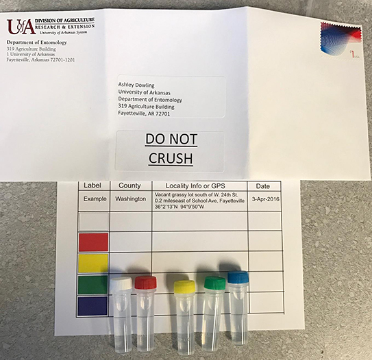
The lids on the vials are color-coded to correspond to the rows on the locality card. so, if you are out at a park and find a tick crawling on your pants, and you collect into the vial with the red lid, you would then record the locality information for the park in the row starting with the red box. If you find more than one tick at the same park on the same day, all ticks can go into the same vial. Likewise, if you were spending multiple days in an area (e.g., on a camping trip), all ticks from that same area over multiple days can go in the same vial. In this case, be sure to record the date range in the date column on the card. The only reason for using different vials is if you collect ticks at different places or at different times of year (e.g., spring, summer, fall). It is very important to properly record the locality information for your ticks, because this is what we'll use to identify areas that may pose greater risks for tickborne diseases. Below are some more specifics about how to provide the best locality information possible
Recording Locality Information
Information about where the tick was collected is some of the most important data we will gather during this project. For this project, there are several pieces of inforamtion we'd like to have for all ticks. The first is the county they were collected in, which is primarily for reporting because we obviously want more specific location information. Second, the date is important because it allows us to get a better idea of peak tick activity, which is different among the species of ticks commonly encountered in Arkansas. Third, some information about the habitat where there tick was found. Was it during a hike in the woods, or out in a grassy field? Was it pulled off a dog? Or maybe from a deer during hunting season? This information would go in the "Locality Info or GPS" box on the card. Also in this same box is where you will record the specific locality information so that we can plot it on a map. Typically, this should be detailed enough so that someone could return to the approximate area. Fortunately, with the proliferation of smartphones, it has become much easier to record very specific locality information. Most phones either have preloaded apps that provide GPS coordinates or you can obtain one of many free GPS apps. Below are some screenprints from various phone types that show GPS coordinates. If you do not have a device that can provide coordinates, scroll down past the phone screenshots for more information and examples of this type of data.
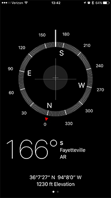
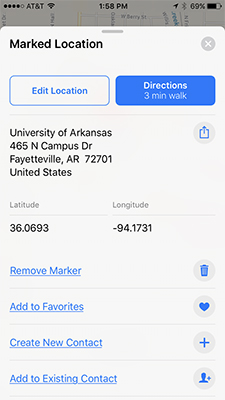
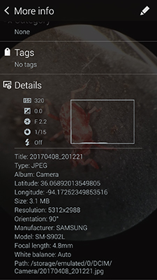
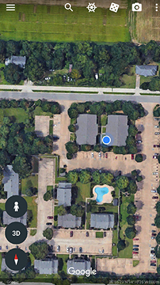
(bottom right corner)
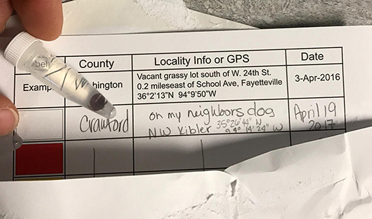
If you don't have a device to obtain GPS, the next best option is to provide a written description of the locality. This could be a street address, nearest crossroads, or a distance and direction from the nearest permanent landmark. Remember, the goal is to provide enough information so someone else could return to the area. Below are four different examples of acceptable locality descriptions.
backyard of 1616 Anywhere St, Springdale
wooded area, Lake Fayetteville Trail, S side of lake, W of botanic garden, Fayetteville
grassy area along County Road 148, about 2 miles W of intersection with State Route 23, Eureka Springs
wooded area, Hemmed-In Hollow, Buffalo National River, about 5 miles hiking from Compton Trailhead off CR 19, 1.0 mile S of Compton Post Office
Sending Your Ticks In
Once you have collected ticks into all five vials in the kit and filled out the locality car, place the card and vials in the provided envelope, and seal the envelope. The envelope with the vials and card will require $1 in postage to arrive to our lab. With the thousands of kits sent out, it was too costly to provide postage and we are hoping this will not keep you from mailing it into us. To insure the envelope does not pop open during transit, please add a layer of tape to the flap and then drop it in the mailbox. Alternatively, you can place the vials and card in a ziploc bag and drop them off at your nearest county extension office and we will get the kit from the office. Also, we will try and stock the extension offices with tick kits so when dropping off, you can obtain a new kit(s) to continue collecting for our project. We'd prefer that you wait until using all five vials before returning the kit to us, however, if by the end of the year you haven't used all the vials, go ahead and send what you have collected so that we can process the ticks and make the data available.
These materials are not endorsed, approved, sponsored, or provided by or on behalf of the University of Arkansas Division of Agriculture and the University of Arkansas, Fayetteville. © 2011 - The Dowling Lab